


Marine Ways - Nautical Charts
Descripción de Marine Ways - Nautical Charts
Esta aplicación no está afiliada a NOAA y no representa a ninguna entidad gubernamental.
Esta aplicación utiliza gráficos disponibles gratuitamente de la NOAA y otras fuentes que se enumeran a continuación.
https://charts.noaa.gov/ENCs/ENCs.shtml
https://www.linz.govt.nz/
https://www.weather.gov/
Descargo de responsabilidad sobre cartas de navegación de la NOAA:
NOAA ENC Online no está certificado para navegación. Las capturas de pantalla de las ENC que se muestran aquí NO cumplen con los requisitos de transporte de cartas para embarcaciones comerciales reguladas según los Títulos 33 y 46 del Código de Regulaciones Federales.
¡Marine Ways Boating es la mejor aplicación de planificación y navegación marina! En esta aplicación obtendrás acceso a:
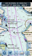
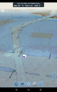
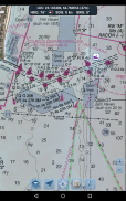
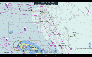
CARTAS DE NAVEGACIÓN
- Cartas de Estados Unidos proporcionadas por la Administración Nacional Oceánica y Atmosférica (NOAA)
https://charts.noaa.gov/ENCs/ENCs.shtml
- Cartas de Nueva Zelanda proporcionadas por Land Information New Zealand (LINZ)
https://www.linz.govt.nz/
Tipos de gráficos:
- Cartas de navegación electrónicas (ENC) de NOAA (el producto de cartografía electrónica más nuevo y potente de NOAA).
https://charts.noaa.gov/ENCs/ENCs.shtml
https://nauticalcharts.noaa.gov/
- Cartas clásicas de la NOAA (incluidas las versiones diurna, roja, anochecer, nocturna y gris).
- Gráficos LINZ (disponibles actualmente solo en versiones de día, anochecer y noche)
https://www.linz.govt.nz/
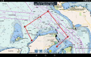
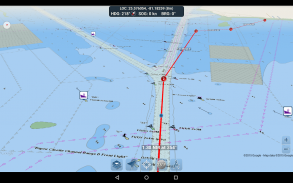
HERRAMIENTAS DE PLANIFICACIÓN DE RUTAS
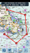
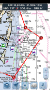
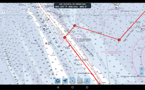
-Trazado de ruta. Mantenga presionado el mapa durante un segundo para trazar sus puntos de referencia. Para formar una ruta, continúe tocando y manteniendo presionado el mapa en diferentes áreas. La distancia y el rumbo se calculan y muestran convenientemente para cada tramo a medida que agrega, ajusta o elimina puntos de referencia.
-Modo viaje. Centra automáticamente el mapa en tu posición actual a medida que te mueves. Utilice el modo de viaje para ver qué tan cerca está siguiendo su ruta trazada en tiempo real.
-Resumen del tramo de ruta. Una vista cómoda que contiene información detallada de cada tramo que ha trazado, incluidas las coordenadas de inicio y fin, la distancia y el rumbo.
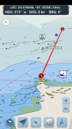
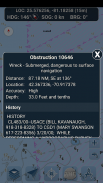
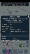
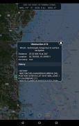
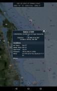
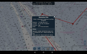
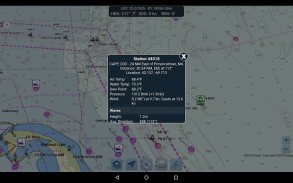
INFORMES DE BOYAS E INFORMACIÓN DE OBSTRUCCIÓN
Datos obtenidos de: https://www.weather.gov/
¡Los marcadores de boyas y obstáculos están convenientemente trazados en su ubicación real en el mapa! ¡Simplemente haga clic en el marcador para ver su información!
- Informes de boyas: obtenga condiciones actuales completas e informes de olas para boyas fijas y a la deriva.
https://www.weather.gov/
- Obstrucciones: obtenga información histórica y de ubicación sobre peligros sumergidos potencialmente peligrosos, incluidas rocas y embarcaciones hundidas.
https://www.weather.gov/
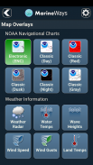
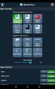
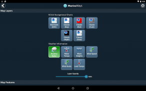
SUPERPOSICIONES DE MAPA MARINO
¡Alterne varios datos marinos superpuestos directamente en el mapa para tener una mejor idea de las condiciones de navegación actuales!
Las superposiciones incluyen:
- Temperatura de la superficie del agua (global)
- Velocidades del viento (solo EE. UU.)
- Ráfagas de viento (solo EE. UU.)
- Wave Heights (solo EE. UU.)
https://www.weather.gov/
UBICACIÓN COMPARTIDA SOBRE EL AGUA / VER OTROS BARCOS
- Muestre su última ubicación conocida, velocidad, rumbo y nombre del barco en el mapa para que otros navegantes de Marine Ways lo vean.
- Vea la última ubicación conocida, velocidad, rumbo y nombre del barco de otros navegantes de Marine Ways, así como su distancia y rumbo desde su ubicación.
- Compartir ubicación está desactivado de forma predeterminada. Cuando esté listo para compartir, actívelo en la configuración general. Para actualizar continuamente su ubicación en el mapa, mantenga la aplicación abierta y enfocada. Actualmente, la aplicación no actualiza su ubicación en segundo plano.
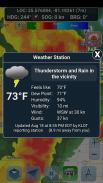
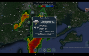
INFORMACIÓN DEL TIEMPO
- Radar de precipitación meteorológica (solo EE. UU. y Hawái). Detecta lluvia y nieve en la zona.
- Estación meteorológica. Informa los datos de la estación de observación más cercana. ¡Temperatura actual, humedad, condiciones climáticas, viento y más! Los datos de observación de la estación están disponibles a nivel mundial.
- Superposición de temperatura de la superficie terrestre. Muestra la temperatura actual de la superficie terrestre (solo EE. UU.).
Antes de utilizar esta aplicación, lea y acepte los siguientes términos de uso/servicio y política de privacidad:
Términos de uso/servicio: http://www.marineways.com/appterms
Política de privacidad: http://www.marineways.com/appprivacy
¡Disfruta la aplicación! Marine Ways también está disponible en la web en http://www.marineways.com
Marine Ways - Nautical Charts - Versión 1.81
(11-06-2025)Marine Ways - Nautical Charts - Información de APK
Version de la app: 1.81Paquete: com.marineways.androidÚltima versión de Marine Ways - Nautical Charts
Otras versiones


Apps en la misma categoría

Quizá también te interese...


